Á Skarðsströnd to Vogur Fellsströnd


Breiðafjörður has been known as the "Foodchest of Iceland" throughout the centuries and there are numerous islands in the fjord. During summer the traffic in the area increases. Excursions through the islands are available. At Skarðsströnd there is a campsite and a service center. Vogur has a magnificent coutry hotel.
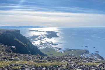
It is possible to start hiking at Á in Skarðsströnd or at Vogur in Fellsströnd. The hike is towards Klofningur, from which there is a spectacular view of Breiðafjörður and Hvammsfjörður.
On the hiking trail itself, there are several beautiful lakes and pleasant nature. At Vogur in Fellsströnd, you will find country hotel and at Á in Skarðsströnd you will find a campsite as well as a service center. No markings can be found along the trail, and there are some parts that can be hard to distinguish. Should be noted that there is a river on the trail that needs to be crossed.
- Area: Skarðsströnd/Fellsströnd, Dalabyggð
- Road number to the starting point: Klofningsvegur (nr. 590)
- Difficulty level: Challenging
- Length: 22.50 km / 13.98 miles
- Elevation: 889 meters / 2916,66 ft elevation
- Markings: No markings along the route
- Duration: 7 hours
- Route type: Small and large rocks, soil and grass substrates, meadows and wetlands
- Obstacles on the way: A step or ledge to climb and an unbridged stream
- Dangers on the way: Rock collapse, wading and wind
- Services in the area: There are services at Á in Skarðsströnd and at Vogur in Fellsströnd
- Illumination: No illumination
- Season: The route is open except during winter time due to weather conditions
- GPS coordinates to the starting point: At Krossá: N65°15.7793 W022°20.7537
- GPS coordinates to the finishing point: At Vogur: N65°10.5871 W022°21.9751


