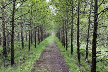
Álfholtsskógur foresty


An outdoor area into Álfholtsskógur forest is a popular destination for travelers in Hvalfjarðarsveit but the accessibility has been improved over the las few years and is defined as an "Open forrest". There are markings along the trails and resting stops. The beginnings of forestry in Álfholtsskógur can be traced back to 1939, and today more than 130 species of trees and flora can be found in the forest.
Hiking trails around Álfholtsskógur are diverse and challenging, but the facilities to enjoy are first class. Resting stops to eat a picnic or only simply enjoy the area, are available and there are markings on the trails. Members of the Skilmannahreppur Forestry Association have worked on marking the routes and improving access for hikers, with the construction of bridges and different steps up the slopes of Álfholtsskógur.
Area: Hvalfjörður.
Road number to the starting point: Akrafjallsvegur (nr. 51).
Level of difficulty: Easy.
Length: 7 km/ 4,34 miles.
Elevation: 0-50 meters /164 ft elevation.
Markings: The route is marked with signs pointing out the way.
Duration: 1 hour and 30 minutes.
Route type: Small rocks, wood chips, grass and mixed substrate.
Obstacles on the way: Steps and bridges on the way.
Services in the area: There are trash bins in the parking area.
Illumination: No illumination.
Season: This hiking trail is open all year round.
GPS coordinates to the starting point: N 64°22.2406 W 021°51.0028.
GPS coordinates to the finishing point: N 64°22.2406 W 021°51.0028.


